Graduate Students Win NASA Earth Science Awards to Support Satellite Data Research
Two aerospace engineering graduate students are recipients of 2020 Future Investigators in NASA Earth and Space Science Technology awards to support their research using Interferometric Synthetic Radar (InSAR) data.
Recipients are awarded a $135,000 stipend over a three-year period which covers tuition, research activities and travel costs to attend workshops and conferences.
NASA grants FINESST awards to graduate students who are pursuing research that is aligned with the NASA Science Mission Directorate in one or more of the following areas: earth sciences, heliophysics, planetary science and astrophysics. The Earth Science Division received 341 proposals and selected 62 for awards.
Both students are using Interferometric Synthetic Radar (InSAR) data – measurements taken of the Earth’s surface using radar satellites – as the basis of their FINESST funded research projects.

Ke Wang
Sophy Wu
Ke Wang was selected for the proposal titled “Integration of InSAR Technique and Storm Surge Modeling to Analyze Anthropogenic Influences on the Texas Coastal Resilience.” Wang said the objective of this research is to use InSAR data to estimate the properties of Earth’s surface on the Texas coast. He will integrate radar measurements with the Advanced Circulation (ADCIRC) modeling framework to provide a new way to analyze how land subsidence and other environmental factors may have contributed to storm surge flooding. Research results will help to inform future decision-making for disaster preparedness and mitigation.
Sophy Wu was selected for the proposal titled “Monitoring Soil Water and Organic Carbon Storage Patterns in the Arctic Foothills, Alaska, Using InSAR.” Wu said she is using the InSAR technique to study the hydrological properties of the Arctic tundra soils. In 2018 and 2019, she joined a UT research team and collected field samples of permafrost soil in the Arctic foothills on the North Slope of Alaska. InSAR data are combined with these field measurements to estimate soil properties like water content and organic carbon. This study will establish a relationship between the amplitude of InSAR-observed surface deformation and the amount of water and soil organic carbon, two keys for predicting future greenhouse gas releases.
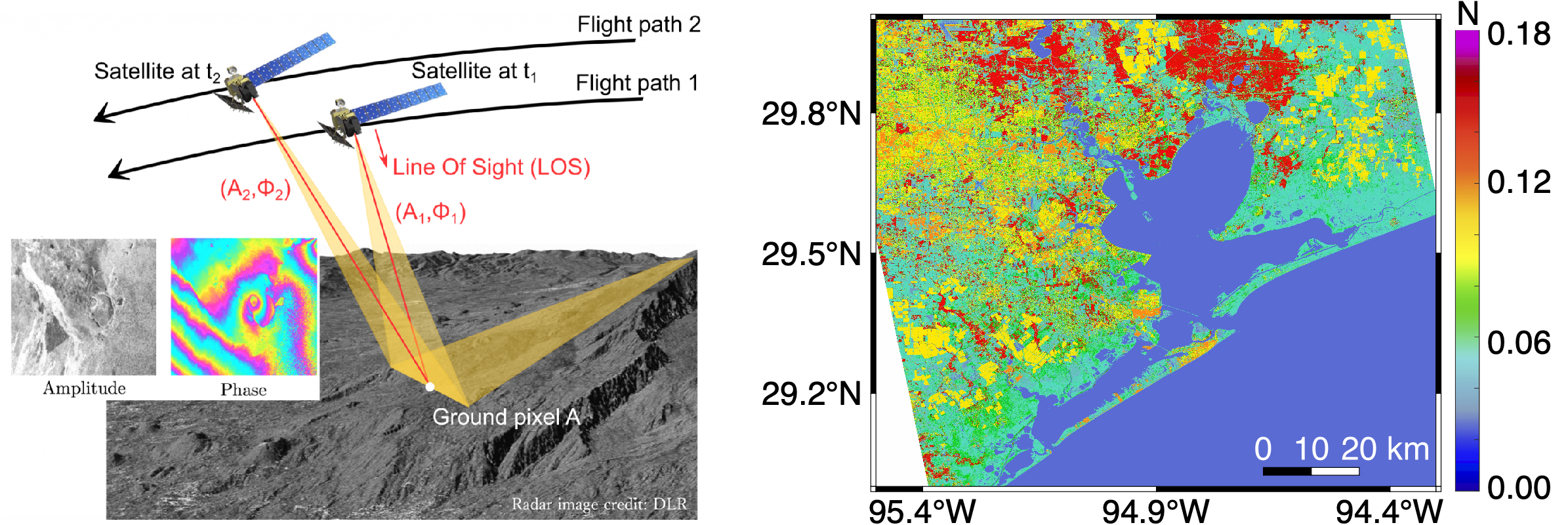
Wang’s research will integrate radar measurements with the Advanced Circulation (ADCIRC) modeling framework to provide a new way to analyze how land subsidence and other environmental factors may have contributed to storm-induced flooding. This image shows the InSAR image geometry (left) and the surface roughness estimated from InSAR data (right).
Wang is advised by assistant professor Jingyi “Ann” Chen and professor Clint Dawson of the Department of Aerospace Engineering and Engineering Mechanics. Wu is also advised by Chen and Bayani Cardenas, a professor of geological sciences at UT Austin. Chen leads the UT Radar Interferomety group housed in UT Austin’s Center for Space Research and Dawson leads the Computational Hydraulics Group at the Oden Institute for Computational Engineering and Sciences.
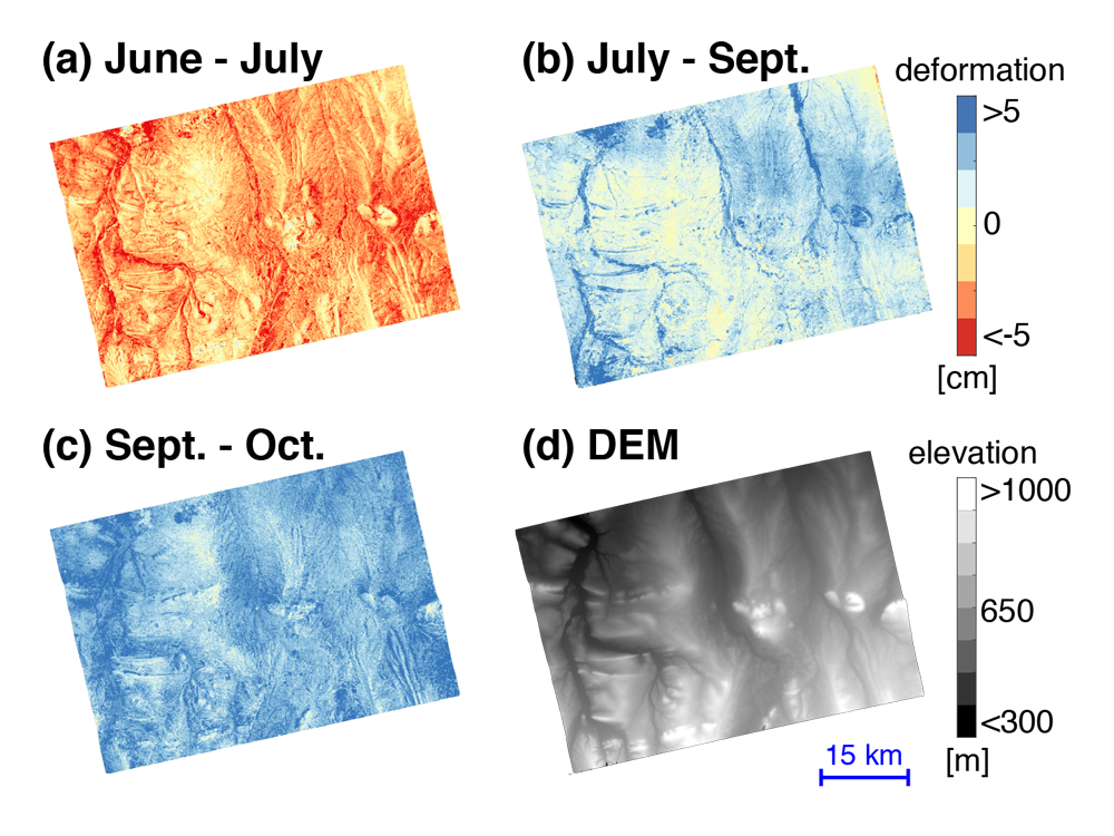
Wu is using the InSAR technique to study the hydrological properties of the Arctic tundra soils. Images: (a) seasonal surface deformation from early June to late July; (b) seasonal surface deformation from late July to September; (c) seasonal surface deformation from September to October; (d) Digital Elevation Model. Red indicates surface subsidence, and blue indicates surface uplift.